Thursday 26 September 2013

Wednesday 21st August: Rest Day

Hike day 7.  (Rest day)

The Czechs enjoy their breakfast including communal bowl of tea.
I had hinted that it would be nice to have a rest day to do some personal admin and to just take in the enormity of the place.  
We liked the Czech and German group.  They were really nice folks. 

The problem with expeditions is that people can become fixated on completing the task. They just want to do it!!  They put their head down and crack on.  This is fine if you are on a military operation or if you are tight for time, but if you have the time, it is just fantastic to be able to take your time as you walk through such an amazing wilderness so that you can take it all in. This way, fleeting glimpses of beautifully sunlit snowcapped mountains become clear and treasured memories.  So my advice to anyone thinking of doing the ACT is to plan to take at least one rest day just so you can absorb it all.  
Our friends the Czechs and German ready to leave whilst we enjoy a rest day.  

We had woke up as planned at 1.30 am in an attempt to see the Northern Lights.  As we expected, the sun was still not setting enough for the sky to become dark enough for the Northern Lights to show up.  Instead the sky maintained a twilight which looked as though the sky was illuminated by a some distant urban sprawl just beyond the mountains. The almost full moon shining its face off didn't help either.  Of course there was no urban sprawl just beyond the mountains; this is, after all, the land of the midnight sun so by 2am we were all back in bed.  
Off they go. 

We awoke again at about 7am and I tabled the idea of a rest day.  I thought this was a good idea for the following reasons: 

Quickly the Czeck and German group become
spots against the enormous backdrop. 
  1. It would give our aching limbs and opportunity to recover.
  2. We could catch up on personal admin such as laundry and boot drying.
  3. We had bumped into the same people along the trail because we were all travelling roughly at the same speed. By having a rest day they could get a day ahead of us and we would be returned to a sense of isolation again, providing there wasn't a bunch of ice cream munching screaming scouts hot on our tails. 
  4. At our current rate of walking we'd be in Sisimiut with four days to kill before our return flights and neither of us were convinced that there was enough to occupy us in Sisimiut for two days let alone four.   
Richard agree that a rest day was a good idea even if he did seem a bit miffed at the thought of unpacking his pack again which he had already prepared for a days hike. 
The stunning sky above the lake in front of the hut. 

We bid the Austrians goodbye at about 9am and the Czechs and German group at about 10.40am.  With the Czech group we exchanged emails and said how nice it would be to meet up in Sisimiut. I took a few group photographs of them and we watched as they walked around the edge of the lake.  Long before they had reached the low saddle of land in the distance at the head of the lake they had become tiny spots of colour against the enormous Greenlandic background.  Our world felt strangely silent once again.  
One of my fish pics

Fish pic
I spent the rest of the morning washing myself, washing some clothes and trying to decide what feast to prepare for lunch.  I also took some more underwater photographs.  I wasn't silly enough to risk the icy water for a swim so the pictures were taken simply by laying on my stomach on a rock at the lake edge and submersing my arms into the chilly water which could have been only a few degrees above freezing.  I got some interesting pictures though. However, I don't think Jacques Cousteau has anything to worry about.   
Not an aquarium but the crystal clear water of the lake. 
One of the little fish.  Not sure of the species. 
Clear water. 
Somewhat less than camera shy fish of the lake. 
Another fish pic

In the afternoon, I went for a short walk around the area of the hut.  Leaving my boots to continue drying out this was done in my crocks so I didn't venture too far. I walked to the river which flowed out of the lake which had created a narrow gorge which was steep sided and deep in a couple of places.  The water flowed fast and amazingly clear. Had the weather been a bit warmer this would have been an ideal place for a dip. My little walk took me up the small hill behind the large hut and towards the smaller hut. 
The ground around the hut is littered with several half decomposed dog turds and there was even the mostly decomposed remains of a sled dog who had most probably become injured.  You simply can't call a vet out here so clearly they use their own initiative to put an injured dog out of its misery.   

The rest of the day was spent reading, eating, doing a few odd jobs regarding kit, and playing a few card games.  I went to bed at about 11pm feeling refreshed and very grateful for having the idea of a rest day.   

The mountains behind the lake hut. 
The river flowing out of the lake
One of the deep clear pools in the little ravine


Clear pools in the ravine.  Just too cold for dip. 


Remains of a sled dog.  
What a location for a rest day.  The saddle of land in the distance over which we'll climb tomorrow. 


Tuesday 20th August. Eqalugaarniarfik to Innajuattoq

Hike day 6  Eqalugaarniarfik to Innajuattoq

A beautiful clear day 6. What views. 
I awoke at about 6am to the usual mountain hut noises.  The Czechs were still sleeping so we made breakfast and packed our packs as quietly as we could.  The day started with a steep but enjoyable climb up the mountain directly behind the hut to the north. 
What looked like a lake in the valley below the hut is in fact the head of a tidal fjord.  


The view from the hut down to the fjord. Looking South West. 
The view from the back of the hut to the morning's climb. Looking North.
Some years ago, apparently, there was a hydroelectric project at one of the lakes in the mountains and some of the heavy equipment was landed on the shore of the fjord below us and a bulldozed track was constructed to move heavy machinery from the fjord to the project site.  The Paddy Dillon guide refers to the ugly scar left by the bulldozers.  As far we saw, this track has, for the most part, become overgrown again.  If we didn't know it was there we wouldn't have spotted it.  So fear not, it is not the blight that it, perhaps, once was. 

Snowcapped peaks to the north
from the hut at Eqalugaarniarfik 
The path does cross the old bulldozed track, but it has largely blended back in to the surroundings.  The path leads due north and once the summit of the climb is reached the path bends around to the left to face west at which point the path levels out over bare rock before descending slightly past several small lakes.  As we skirted around one of the small lake we came across the two Austrian chaps. They had decided not to stay at the hut and instead had pushed on.  As they had clearly enjoyed a long lay-in their decision was probably motivated more by a desired to escape Richard's snoring which, by this time, was becoming legendary and was beginning to even attract the somewhat unwanted attention of reindeer, muskox and bears (only joking).  The Austrians had camped in a lovely sheltered spot by one of the mountain lakes.  We said "hello" and "See you later" and carried on leaving them to have their breakfast.  

Near the top of the climb before the lakes. 
A short time after the lake where the Austrian's had camped the path descends into a stunning valley with a huge lake around which the path traverses to head in a northerly direction again. To our front were huge rock faces with snowcapped peaks beyond.  A truly awe-inspiring view which words and photos simply cannot do justice to.  After a short period of skirting around the lake, the path climbs over a low spur of land before dropping down to another stunning lake surrounded by rugged, steep and crumbly looking crags. 

Snowcapped mountains to the north.
For what ever reason, I was beginning to experience some pain in my ankles, knees and hips.  No matter what I did, I couldn't seem to get comfortable and I resorted to taking a few pain killers to dull the discomfort.  These did the trick and after a while the discomfort had gone, but I still felt as though I was running on empty.  I think this is where the difference in people taking part in an expedition such as this is highlighted.  There is always the temptation to try and go at the speed of the fastest person even though the sensible way is to go at the speed of the slowest.  I also hate to impose myself on others so I will happily go hungry until someone else says that they want to stop for food.  I need to be more assertive in these situations and stop for food more often as I clearly have the sort of metabolism that needs refuelling often.  

Looking back East from near the top of the climb to the lake.
This is above last night's hut. 
The small mountain lakes near where the Austrian camped. 
We continued on a path that was mostly boggy with a few firm patches. After a few kilometres the path skirted round to the left at the foot of a large spur of land and comes abruptly to a deep fast flowing river which flows out of the lake we have just walked along.  We followed the river keeping it on our right until it flowed into another smaller lake which had steep rock faces on its northern shore and a more gently sloping shoreline on its southern side where we were walking. From the shoreline on the southern side of the lake the ground is relatively flat for a few hundred metres before climbing steeply to surrounding ridges and summits.  This flat land, which is where were are forced to walk, is a large area of wetland and bog where the path is hardly discernible.    

The conditions under food were demanding for the latter part of today as we had to cross a large section of boggy ground so found ourselves ankle deep in icy water for a few kilometres. The valley was incredibly beautiful with crystal clear lakes, pools and rivers.  We saw at least eight reindeer including several calves.

Cairn and snowcapped mountains
As we approached the head of the the smaller lake, the path began to ascend again and conditions under foot began to get drier and firmer. The path skirts around the northern edge of another spur of land below which the smaller lake empties via a narrow but steep sided ravine. 

As we round the spur to head in a westerly direction again, we can see one of the mountain huts.  This location spoils the Arctic Circle Trail hiker by providing you with a choice of two huts to use.  The first hut is by far the smaller of the two and is anchored to the rock on top of a small hill overlooking the next valley.  We decided to walk a bit further to another hut which is located on the shoreline of the next lake.  This is by far the tidiest hut on the trail and the word "hut" just doesn't do it justice.  

Looking north.  Cairn and mountains.
The hut has a toilet (plastic bag type again just like the others), a large sitting areas which can sleep several people and a separate dorm which can sleep about another ten people in bunk beds.   The outlook from the larger of the two huts is simply beautiful.  It is built right on the edge of a small lake which has an island.  The northern and southern edges of the lake are hemmed in by steep rugged slopes whilst the head of the lake is formed by a low saddle which links the northern and southern slopes. 

Looking North West. 
We arrived at the hut at about 4.30pm and were joined by the two Austrians just over an hour later and by the Czech and German group at about 6.30pm.  

Whilst we still had the hut to ourselves, we were able to have a decent wash in the lake, do some laundry and cook supper.  I even tested out the waterproof feature on my camera by trying to take pictures of the usually tame 'minnows' in the lake who didn't seem to be too camera shy.  

We chatted to the others and on the recommendation of one the Czechs we decided to set an alarm to wake us up in the early hours in an attempt to see the Northern Lights.  I was a bit dubious about this as the sun hardly sets at this time of year so it was doubtful if the sky would get dark enough for the lights to be visible. Anyway, we agreed it was worth a try as it was such a clear evening. 

Rocks, snow and mountains.
Before turning in, we gave some of our fuel to the Czechs as they hadn't brought enough and it was looking as though we had brought too much.  This lightened the load by about a kilo so it was worth doing. It was also nice to be able to help out some fellow trail hikers.  

It is important to note that the area around Sisimiut to the west is famed for its dog sledding and this is perhaps the first location that one is reminded that Sisimiut is getting closer.  Around the hut is the evidence of hunting and dog sledding; two very popular pass times for the native Greenlanders.

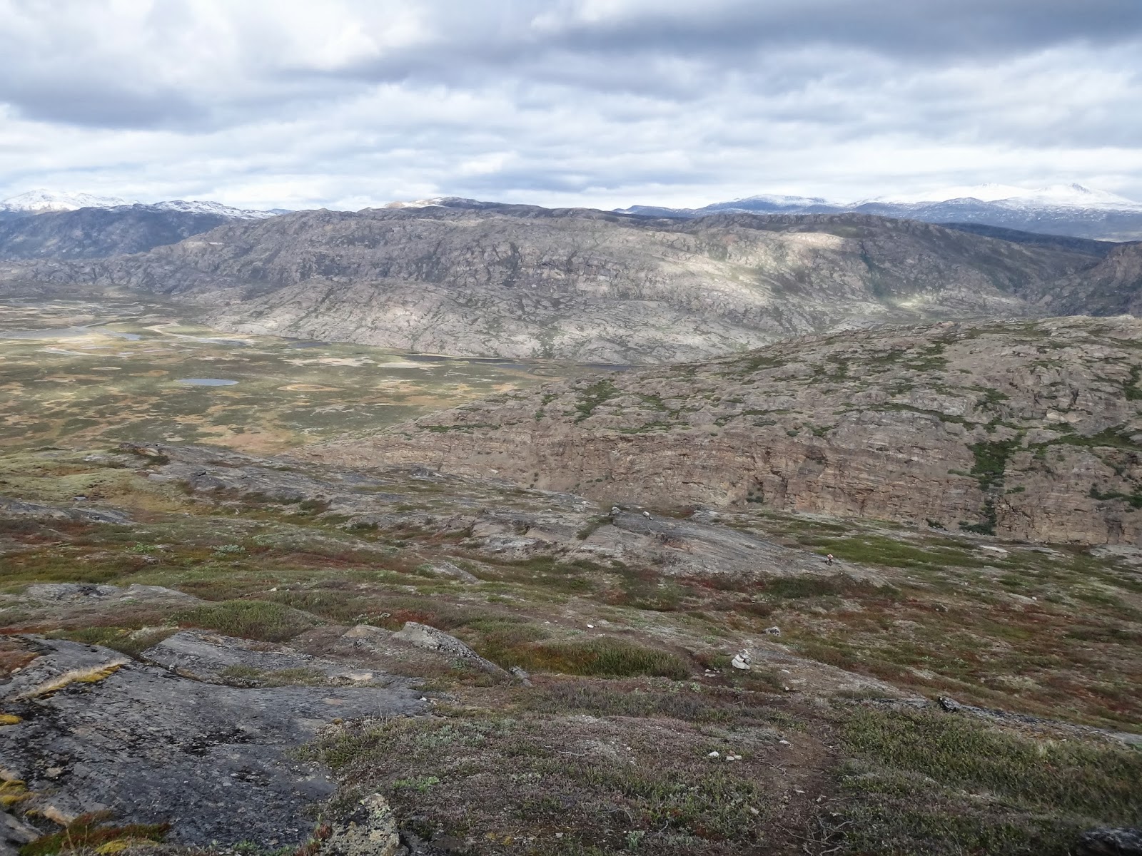
The flat (ish) land and the sudden cliffs
on the southern shore of the lake.
You can just make out a small group of reindeer. 


One of the many little streams we'd cross. 

The deep fast flowing river which empties from the large lake.
Surrounded by craggy rock faces. 


Expanse of boggy ground. 

The northern shoreline of the lake with bog in the foreground. 

Multitude of lakes and bogs to our north.  Just before the hut. 

View of the Lake hut with the low saddle of land at the far end of the lake. 

The Lake Hut.  Great spot for a rest day. 

Lake hut.  Steep sided cliffs to the north and south with low laying saddle to the west.  Just awesome. 

Wet boots and clothes drying in the sun.  A great place to do your laundry. 

The Lake Hut.  

The crystal clear water in the lake.  With little fish. 

Talk about curiosity. 

One of the little fish in the lake. 

Monday 19th August: Ikkattooq to Eqalugaarniarfik

Hike day 5: a lovely day.

Looking back towards the hut at Ikkattooq
The two Austrian guys were the first to get up this morning.  They didn't look too please as Richard's snoring had been of epic proportions last night.  We all moved around each other preparing breakfast and organising our packs.  We won some brownie points from the Austrians because it transpired that they were in danger of running out of stove fuel so we were able to boil up some water for them for which they were very grateful. 

After breakfast, the Austrians were the first to leave the comfort of the mountain hut. I had to treat my feet as the soaking they had received in the lake a couple of days ago was beginning to make my feet rot and I was beginning to shed skin.  After everything was organised and feet had been dusted with powder, we left the hut about 50 minutes after the Austrians.
It was only when we stepped outside the hut to leave that I noticed that it was anchored to the ground with steel cables to prevent it from blowing off the ridge in high high winds. 

The hill top cairns with snow capped mountains to the north. 
Although the hut is already high in the mountains the route starts with a steep ascent and then flattens off as it passes a number of small mountain lakes and pools. On the way up we stopped to take in the view of the hut and the tents against the enormous background.  

At the top of this ascent we stopped and took in the view.  We have been hiking for five days and yet when we look back to where we have come from we could just make out the glacier beyond the unseen Kangerlussuaq. We continued along the tops with the path undulating and switching from tufty grass to bare rock and hardened mud flows. After a couple of kilometres the view opens out over the vast flat bottomed valley called Ole's Lakseelv.  We could also see the snow capped mountains of Pingup Sallia and Pingu to the north.  From here the path descended steeply over boggy patches and boulders.  On our descent we caught our first sighting of an Arctic Hare.  It looked more like a rabbit than a hare with the exception of being white. On reaching the valley floor which barely sits above sea level we saw a female reindeer with a calf.   As seems to be normal with deer, they watched us for a while with some curiosity before running away for a few seconds before stopping to check us out again.  No wonder they are easy to shoot.  The poor things are just too damn curious. 
Looking back to where we started.
The glacier is just visible in the distance. 
Looking down in to the flat bottomed valley of Ole's Lakseelv
We headed for a point on the valley floor marked on the map as a ford.  This is one of the recommended spots for making the crossing across the river that flows through the valley. The going was relatively easy although forcing our way through dwarf willow was becoming a bit tedious. On our way to the river crossing we came across two Danish guys, a farther and son team we thought unless they just had a very uncanny resemblance to each other. They informed us that the next mountain hut had no fresh water close by as one of the mountain streams that had flowed conveniently close to the hut had dried up as a result of a hydroelectric scheme some miles up stream. 
We pressed on and when we reached the river we met the two Austrians again who had just completed their river crossing.  We exchanged hellos and they headed off.    
The walls of the valley of Ole's Lakseelv
We surveyed the river for a suitable place to cross.  There is, according to the guidebook a small wooden foot bridge about two kilometres down stream.  However, this seems to be a bit of crazy country planning as no one seems to use it.  Everyone we met and spoke to had headed straight for the ford.  

Richard half way through the river crossing.

Me crossing the river. 
Cotton Grass on the valley floor. 
We have both trained as Mountain Leaders so we practiced what we preach and employed good safe practice when crossing the river. We removed boots, socks and as I didn't have zip off bottoms to my trousers, I removed my trousers too.  We both donned our crocs, undid the waist belts on our packs and slackened off the shoulder straps. We crossed individually using our walking poles for additional support. The water was cold. It had flowed out of a huge lake a few hundred metres away from us and it teemed with small fish.  Only a few days ago this water rushing past my feet was probably ice.

Once across the river we dried our feet and collected about four litres of water each to carry to the hut.  This added another four kilograms to our still heavy packs.

The path from the river took us through some large patches of boggy ground with large clumps of what I think is called Cotton Grass or Bog Cotton due to its fluffy white flower heads. The flies started to be a nuisance along this stretch of the trail. We knew they could be a problem but we had not experienced any problems with flies, mozzies or midges up to this point. The "bog flies" didn't seem to bit but their irritation come from the fact that they can't seem to help flying into your ears, nose and eyes.  For the first time I donned my head net and applied some insect repellent.  The repellent didn't seem to work so I can recommend having a head net if you are thinking of doing this hike. 

Cotton Grass (Bog Cotton) on the valley floor. 

We followed the northern edge of the valley floor which took us through bogs, dried up lake beds and dried up stream beds which offered lots of interesting animal tracks. After about two kilometres the route starts to ascend a gentle gradient which runs up the side of a bigger spur.  The path bends round the right and take you over a low shoulder of the spur where, quite suddenly, the hut comes into view. 

The hut is very tidy and appears to be quite spacious with a toilet.  However, the space isn't particularly well organised as the sleeping platform only provides space enough for four people.  The view from the front door of the hut is simply breath taking and photography just doesn't do it justice. 

Today was another one of those days where you have a little psychological milestone because we passed the halfway point today. Only 82km to go.  So far, I am loving this experience.  The sense of isolation and remoteness is profound. 

First sighting of the Eqalugaarniarfik hut. 
On arriving at the hut we were a bit surprised not to see the two Austrian guys.  They had clearly decided to push on a bit further before settling down for the night. We had been at the hut for about 3 hours when the Czech and German group turned up.  With plenty of floor space everyone was able to find somewhere to sleep. Tomorrow is another longish day (20km) with a steep ascent early on and the potential for some tricky navigation around lakes, streams and bogs.        


The Eqalugaarniarfik hut set against the mountain.


The view from the Eqalugaarniarfik hut.

The sun still high in the sky at 9pm.

View from the Eqalugaarniarfik hut
with our flag fluttering..

Supper at the Eqalugaarniarfik hut.


The sun getting lower over Ole's Lakseelv. As seen from the hut. 

View from the hut.